The Four Spheres of the Earth

Atmosphere, Biosphere, Hydrosphere, Lithosphere

The area near the surface of the earth can be divided up into four inter-connected "geo-spheres":

Lithosphere

The lithosphere is the solid, rocky crust covering entire planet. This crust is inorganic and is composed of minerals. It covers the entire surface of the earth from the top of Mount Everest to the bottom of the Mariana Trench, all land above sea-level and below the oceans. This also discussed in Geology.

Hydrosphere

The hydrosphere is composed of all of the water on or near the earth. This includes the oceans, rivers, lakes, and even the moisture in the air. Ninety-seven percent of the earth's water is in the oceans. The remaining three percent is fresh water; three-quarters of the fresh water is solid and exists in ice sheets

Biosphere

The biosphere is composed of all living organisms. Plants, animals, and one-celled organisms are all part of the biosphere. Most of the planet's life is found from three meters below the ground to thirty meters above it and in the top 200 meters of the oceans and seas.

Atmosphere

The atmosphere is the body of air which surrounds our planet. Most of our atmosphere is located close to the earth's surface where it is most dense. The air of our planet is 79% nitrogen and just under 21% oxygen; the small amount remaining is composed of carbon dioxide and other gasses.

All four spheres can be and often are present in a single location. For example, a piece of soil will of course have mineral material from the lithosphere. Additionally, there will be elements of the hydrosphere present as moisture within the soil, the biosphere as insects and plants, and even the atmosphere as pockets of air between soil pieces.

Water vapor

The earth is surrounded by the atmosphere, which at ground level we call air, and which is a mixture of gases, 78% nitrogen and just under 21% oxygen; the small amount remaining is composed of carbon dioxide and other gases. One gas which varies considerably in its presence is water vapor, that is, liquid water turned into a gas. Water vapor varies between 1-4%.

A liquid has its molecules relatively close together, exerting a force of attraction which prevents them from leaving thru the surface of that liquid. These molecules move rapidly at different speeds, hitting each other and bouncing off each other.

The warmer the molecule, the faster it moves, and the faster it moves, the warmer it is. A thermometer is a man-made gauge registering what we call temperature, and we discovered much later that temperature of a substance is a man-made arbitrary meazure of the average energy of the molecules of that substance.

The fastest molecules in a liquid may be sufficiently fast to break thru the surface of the liquid and escape. Such escapes accumulate and gradually the liquid disappears, a process called evaporation. With evaporation, liquid like water turns into a gas called water vapor, and the water molecules pass thru the liquid surface, escaping the attractive forces completely, free to roam wherever the molecule 'wishes'. The only restriction is that it travels in a straight line until it hits something and bounces in a new direction, or until the Earth's gravitational pull draws it downward. It is the Earth's gravitational pull which stops the gases drifting off from our Planet into Space.

These vapor molecules or gas molecules are much much farther apart than are liquid molecules, and so the forces of attraction between them are much much weaker, allowing them to roam freely. However, if their energy diminishes, slowing them down, their speed may not be enough to overcome their attraction for each other, and they may reform a liquid, condensing. Water vapor in the air condenses as dew on cold surfaces like blades of grass or glass windows, or dust in the sky (forming clouds and rain). Contact with such a cold surfaces suddenly drops their energy, with several molecules coalescing into liquid, and thousands more collisions adding their numbers to form a water droplet.

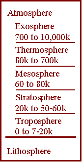
Atmospheric layers

Since the Earth's gravitational pull draws the gases towards the ground, our atmosphere's gases are most dense close to the earth's surface.

not found There are five distinct layers of the atmosphere:
Pauses: Between each two layers of the atmosphere is a transition, called a 'pause' which is named after the layer below it: tropopause, stratopause, mesopause, thermopause.

The atmosphere's constituents

The earth's atmosphere near the surface is composed primarily of 78% Nitrogen N2 and Oxygen O2 just under 21% . These gases are freely moving molecules each composed of two similar atoms linked together, N=N and O=O, where "=" represents the sharing of 2 electrons.

The next gas is Argon, at just under 1%, an inert gas with its molecules being single atoms. Then comes carbon dioxide, O=C=O but usually written as CO2, at just under 0.04%.

Gases are extracted from the atmosphere by compressing and chilling the air below the condensation points of the gases, at which they condense into liquids. Liquid nitrogen is used for freezing such things as embryos and livestock sperm. Bottled oxygen is used for ambulance work,

Argon is used for welding, light bulbs,
We breathe in oxygen, using it to turn sugar into energy, water and carbon dioxide, the latter two being breathed out. Plants absorb CO2 during sunlight, converting it to sugar while releasing oxygen. However, for 24 hours a day, they use oxygen to 'burn' sugar to release energy and CO2. (It is the practice in hospitals to remove flowers and plants from the ward at night to avoid depleting oxygen and raising CO2 levels.)

Older readers may remember the time when ice cream was kept in canvas cylinders chilled with solid white carbon dioxide, another gas of the atmosphere. (Remember the pennies 'dancing' on the solid carbon dioxide, as the gas 'boiled' beneath them ?)

Together, the 4 gases, N2, O2, Ar, and CO2, comprise about 100% of non-watergases in the lower atmosphere.

Here is the approximate composition of the lower atmosphere.

GasProportion

Water vapor
Water vapor

Excluding water
Nitrogen
Oxygen
Argon
Carbon Dioxide
Neon
Helium
Methane
Hydrogen
Nitrous Oxide
Ozone


about 1-4%


78.084%
20.95%
0.934%
0.036%
0.0018%
0.0005%
0.00017%
0.00005%
0.00003%
0.000004%
just over 100%
 

In addition, water vapor is variable but typically makes up about 1-4% of the atmosphere.

Since we cannot smell air, an ability which would be a hindrance when trying to pick up useful scents, all of these atmospheric gases are odorless, including methane.

Wind Causes

Air moves from regions of higher pressure to regions of lower pressure.
On a weather map, such as shown on TV, there are lines called isobars, which represent areas of equal pressure along the line. Since air moves from higher pressure to lower pressure, the wind must move across these isobars. Because of the rotation of the Earth, usually the direction is not perpendicular to the isobars but slanted across it. In the Southern hemisphere, below the equator, around a High Pressure Zone, the wind moves outwards anti-clockwise.

Around a Low Pressure Zone, the wind moves inwards clockwise. (Just memorize the anticlockwise of the High Pressure Zone.) In the northern hemisphere the direction is opposite, with the HPZ wind moving outwards clockwise. Just memorize one of the two movements in your hemisphere, and the other 3 can be worked out from this.

This rotation around highs and lows is due to the Coriolis effect, a force deflecting wind from its straight path from high to low pressure.
 
HemisphereHigh
outwards
Low
inwards
Southern
Northern
anticlockwise
clockwise
clockwise
anticlockwise

In addition to the Coriolis effect, there is the frictional force which slows wind down as it travels over the Earth’s surface.

Air pressure is meazured with a barometer. Air pressure is caused simply by air molecules hitting objects such as the barometer or our skin, like millions of tiny tennis balls rocketing thru space in all directions.
If the sun shines on dark rock, the rock will become hot and heat the air above it. Hotter molecules move faster, hit harder, and thus exert higher pressure. BUT higher temperature increases the velocity of molecules, causing the air to expand, becoming less dense (fewer molecules per cubic metre), and so dropping the pressure. Thus warm air tends to have a lower pressure than cold air.
Wind strength can vary from a light breeze to hurricane force and is measured with the Beaufort Wind Scale.

Winds are named from the direction from which they originate. (Ocean swells are named from the direction towards which they go.) For example, a westerly is a wind coming from the west and blowing toward the east. Wind speed is measured with an anemometer and its direction is determined with a wind vane.

Since wind is produced by differences in air pressure, it is important to understand that concept when studying wind as well. Air pressure is created by the number of gas molecules and their momentum, as given by mass and velocity. The number of molecules depends on air density, while the velocity increases with the temperature. (Temperaure is nothing more than a man-made meazure of the kinetic energy of molecules. This is discussed in detail in Physics >> Matter, where a neat proof is given.)

In 1643, Evangelista Torricelli, a student of Galileo developed the mercury barometer to measure air pressure after studying water and pumps in mining operations. Using similar instruments today, scientists are able to measure normal sea level pressure at about 1013.2 millibars (force per square meter of surface area).

Pressure Gradient

Within the atmosphere, there are several forces affecting the speed and direction of winds. The most important though is the Earth’s gravitational force. As gravity compresses the Earth’s atmosphere, it creates air pressure, the driving force of wind. Without gravity pulling the air down, there would be no atmosphere or air pressure and thus, no wind.

The force actually responsible for causing the movement of air though is the differences in air pressure (pressure gradient force). Differences in air pressure and the pressure gradient force are caused by the unequal heating of the Earth’s surface. Find yourself a large area of dark-colored rock such as basalt or bitumen, on a hot sunny day. Do one of several things: By these means you should be able to discern the air movement coming from outside to the center of the dark rock, then rising upward for considerable distance.

This demonstrates:
This inward-moving air is the equivalent of a breeze or light wind.

A similar occurrence happens along coastal areas. In the morning the land heats faster than the sea, so air above the land rises, causing an inward breeze called a sea breeze. At night the land cools faster than the sea, so the air above the sea rises, while the air above the land sinks, cools and then moves in under the rising sea air, causing a land breeze. So sea breezes occur in the day and land breezes at night.

Similar events occur on a massive scale. Differences in air pressure and the pressure gradient force are caused by the unequal heating of the Earth’s surface when incoming solar radiation concentrates at the equator. Because of the energy surplus at low latitudes for example, the air there is warmer than that at the poles. Warm air is less dense and has a lower barometric pressure than the cold air at high latitudes. These differences in barometric pressure are what create the pressure gradient force and wind as air constantly moves between areas of high and low pressure.

Isobars

[iso = same; bar = pressure; isobar = line showing equal pressure at all points along it.]
To show wind speeds, the pressure gradient is plotted onto weather maps using isobars. Each isobar has its own pressure reading, so adjacent isobars show pressure rising or falling in equal amounts. Because adjacent bars reveal equal changes in pressure, bars spaced far apart show this equal change spread over a long distance, indicating a slow change in pressure and therefore light winds. Those bars close together show changes over short distances, and therefore rapid pressure change, a steep pressure gradient and strong winds.

Finally, the Coriolis force and friction both significantly affect wind across the globe. The Coriolis force makes wind deflect from its straight path between high and low pressure areas and the friction force slows wind down as it travels over the Earth’s surface.

Upper Level Winds

Within the atmosphere, there are different levels of air circulation. However those in the middle and upper troposphere are an important part of the entire atmosphere's air circulation. To map these circulation patterns upper air pressure maps use 500 millibars (mb) as a reference point. This means that the height above sea level is plotted only in areas with an air pressure level of 500 mb. For example, over an ocean 500 mb could be 5,500m into the atmosphere but over land it could be 5,800m. By contrast, surface weather maps plot pressure differences based at a fixed elevation, usually sea level.

The 500 mb level is important for winds because by analyzing upper level winds, meteorologists can learn more about weather conditions at the Earth’s surface. Frequently, these upper level winds generate the weather and wind patterns at the surface.

Two upper level wind patterns that are important to meteorologists are Rossby waves and the jet stream. Rossby waves are significant because they bring cold air south and warm air north, creating a difference in air pressure and wind. These waves develop along the jet stream.

Local and Regional Winds

In addition to low and upper level global wind patterns, there are various types of local winds around the world. Land-sea breezes that occur on most coastlines are explained above.

Mountain-valley breezes are another localized wind pattern. These winds are caused when mountain air cools quickly at night and flows down into valleys. Thick tree-planting in an arrow-shape, can help divert these cold air movements away from fruit trees. In addition, valley air gains heat quickly during the day and it rises upslope creating afternoon breezes.

Some other examples of local winds include Southern California’s warm and dry Santa Ana Winds, the cold and dry mistral wind of France’s Rhône Valley, the very cold, usually dry bora wind on the eastern coast of the Adriatic Sea, the Chinook winds in North America, and 450C winds from Central Australia.

Winds can also occur on a large regional scale. One example of this type of wind would be katabatic winds. These are winds caused by gravity and are sometimes called drainage winds because they drain down a valley or slope when dense, cold air at high elevations flows downhill by gravity. These winds are usually stronger than mountain-valley breezes and occur over larger areas such as a plateau or highland. Examples of katabatic winds are those that blow off of Antarctica and Greenland’s vast ice sheets.

The seasonally shifting monsoonal winds found over Southeast Asia, Indonesia, India, northern Australia, and equatorial Africa are another example of regional winds because they are confined to the larger region of the tropics as opposed to just India for example.

Whether winds are local, regional, or global however, they are an important component to atmospheric circulation and play an important role in human life on Earth as their flow across vast areas is capable of moving weather, pollutants, and other airborne items worldwide.

You will have noticed that rain is accompanied by wind. High clouds are often made, not of rain droplets, but of ice particles. As these descend as hail, the hail abosrbs the heat from the air, chilling the air. Chilled air becomes more dense, and thus increases the pressure. Increased pressure differences causes winds. Big rain clouds such as cumulo nimbus, generate enormous winds inside themselves, as seen by watching the clouds 'billow and boil' skywards at great speed for many kilometres.

Global Circulation

Solar radiation warms the air over the equator, causing it to rise. The risen air then moes at high altitudes south and north toward the poles. From approximately 20° to 30° North and South latitudes, the air sinks. Then, the air flows along the surface of the earth back toward the equator.

Doldrums

Sailors noticed the stillness of the rising (and not blowing) air near the equator and gave the region the depressing name "doldrums." The doldrums, usually located between 5° north and 5° south of the equator, are also known as the Intertropical Convergence Zone or ITCZ for short. The trade winds converge in the region of the ITCZ, producing convectional storms that produce some of the world's heaviest rainfalls.

The ITCZ moves north and south of the equator depending on the season and solar energy received. The location of the ITCZ can vary as much as 40° to 45° of latitude north or south of the equator based on the pattern of land and ocean. The Intertropical Convergence Zone is also known as the Equatorial Convergence Zone or Intertropical Front.

Horse Latitudes

Between about 30° to 35° north and south of the equator lie the regions known as the horse latitudes or the subtropical high. This region of subsiding dry air and high pressure results in weak winds. Tradition states that sailors gave the region of the subtropical high the name "horse latitudes" because ships relying on wind power stalled; fearful of running out of food and water, sailors threw their horses and cattle overboard to save on provisions. (Did the horses eat corned beef or did sailors eat hay ? So much for "tradition".)

Major deserts of the world, such as the Sahara and the Great Australian Desert, lie under the high pressure of the horse latitudes.

The region is also known as the Calms of Cancer in the northern hemisphere and the Calms of Capricorn in the southern hemisphere.

Trade Winds

Blowing from the subtropical highs or horse latitudes toward the low pressure of the ITCZ are the trade winds. Named from their ability to quickly propel trading ships across the ocean, the trade winds between about 300 latitude and the equator are steady and blow about 18 – 22 kph. In the Northern Hemisphere, the trade winds blow from the northeast and are known as the Northeast Trade Winds; in the Southern Hemisphere, the winds blow from the southeast and are called the Southeast Trade Winds.

Every summer, southern Asia and especially India, is drenched by rain that comes from moist air masses that move in from the surrounding Indian Ocean. These rains, and the air masses that bring them, are known as monsoons.

However, the term monsoon refers not only to the summer rains but to the entire cycle that consists of both summer moist onshore winds and rain from the south as well as the offshore dry winter winds that blow from the continent out to the Indian Ocean.

Air pressure is one of the primary factors. In the summer, a high pressure area lying over the Indian Ocean pushes moist air towards the low pressure over the Asian continent. In winter, the process is reversed, with high pressure over the Tibetan plateau pushing dry air out down the Himalaya and south to the low-pressure over the Indian Ocean. The migration of trade winds and westerlies also contributes to the monsoons.

Smaller monsoons take place in equatorial Africa, northern Australia, and, to a lesser extent, in the southwestern United States.

Almost half of the world's population lives in areas affected by the monsoons of Asia and most of these people are subsistence farmers, so the coming and goings of the monsoon are vital to their livelihood to grow food to feed themselves. Too much or two little rain from the monsoon can mean disaster in the form of flood or famine. Much of the densely populated areas are huge low-lying river deltas such as the Ganges and Brahmaputra Rivers, Irrawaddy, Chao Phraya and Mekong, where rising seas due to cyclones and global warming, can prevent floodwaters from escaping. Huge rapidly-expanding populations force people to farm and fish such areas, or starve. Floods destroy crops and houses, disrupt food supplies and medical services, and foul drinking water, thus bringing diseases such as cholera, typhoid, and increased malaria. The future of these peoples looks bleak.

The wet monsoon, which begins quickly in June, is especially important to India, Bangladesh, and Myanmar (Burma). The monsoon is responsible for almost 90 percent of India's water supply. The rains usually last until September. An interesting social effect is that when a storm lowers the temperature and freshens the atmosphere, the people become relaxed and friendly.