Weather
Air Masses and Fronts
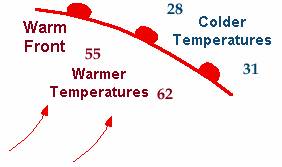 Warm fronts are indicated on weather maps using red semi-circles on a red line, pointing in the direction of travel. The mass of warm air is behind the line, on the side opposite the red semi-circles, and moving in the direction of the semi-circles. This mass of warm air is at higher pressure than the cold air and so is pushing the cold air along.
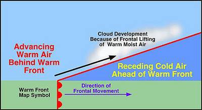 At the same time, there is a tendency for the warm air at the leading edge to rise over the cold air as shown in the picture. Where the two masses of air are in contact the cold air chills the leading warm air, and also the warm air chills as it rises, thus causing condensation of its moisture into droplets which then form clouds. These clouds are seen at the bottom of the warm air.
 Cold fronts are indicated on weather maps using blue triangles on a blue line, pointing in the direction of travel. The mass of cold air is behind the line (on the side opposite to the triangles).
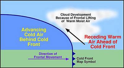 Again, the warm air tends to rise above the cold air. The act of rising in altitude chills the warm air as well as mixing with the cold air, so some moisture condenses to form clouds.
Notice that the cloud shapes are different to those formed by an advancing warm front.
While the clouds often tell us of approaching fronts, it is possible to feel the arrival of a cold front and a warm front by the temperature change. However, do not confuse a wind chill factor for a cold front.If you are perspiring, even a slight warm breeze will feel like a cold front. Therefore when trying to forecast the weather, use as many signs as you can find. While some people profess to use aches in their corns to predict rain, even with cloudless skies we can predict serious rain in 3 or 4 days' time, by watching ants.
What Is a Barometer ?
A barometer is a widely used weather instrument that measures atmospheric pressure (also known as air pressure or barometric pressure) - the weight of the air in the atmosphere.
There are two main types of barometers – the most widely available and reliable Mercury Barometers, or the newer digital friendly Aneroid Barometer.
How does a Barometer Work ?
The classic mercury barometer is typically a glass tube about 3 feet high with one end open and the other end sealed. The tube is filled with mercury. This glass tube sits upside down in a container, called the reservoir, which also contains mercury. The mercury level in the glass tube falls, creating a vacuum at the top. The first barometer of this type was devised by Evangelista Torricelli in 1643.
The barometer works by balancing the weight of mercury in the glass tube against the atmospheric pressure just like a set of scales. If the weight of mercury is less than the atmospheric pressure, the mercury level in the glass tube rises. If the weight of mercury is more than the atmospheric pressure, the mercury level falls.
Atmospheric pressure is basically the weight of air in the atmosphere above the reservoir, so the level of mercury continues to change until the weight of mercury in the glass tube is exactly equal to the weight of air above the reservoir.
In areas of low pressure, air is rising away from the surface of the earth more quickly than it can be replaced by air flowing in from surrounding areas. This reduces the weight of air above the reservoir so the mercury level drops to a lower level.
In contrast, in areas of high pressure, air is sinking toward the surface of the earth more quickly than it can flow out to surrounding areas. There is more air above the reservoir, so the weight of air is higher and the mercury rises to a higher level to balance things out.
Modern Technology and Barometric Pressure
The majority of modern weather instruments – such as weather stations – can measure barometric pressure, but use a digital barometer that uses electrical charges to measure air pressure. This enables them to take multiple accurate recordings of the pressure and produce more accurate weather forecasts.
Using Atmospheric Pressure to Forecast the Weather
Changes in atmospheric pressure are one of the most commonly used ways to forecast changes in the weather because weather patterns are carried around in regions of high and low pressure. Weather maps use lines of equal pressure called isobars to indicate areas of equal pressure.
A slowly rising atmospheric pressure, over a week or two, typically indicates settled weather that will last a long time. A sudden drop in atmospheric pressure over a few hours often forecasts an approaching storm, which will not last long, with heavy rain and strong winds.
Pioneering meteorologist Vice-Admiral Robert Fitzroy once noted: "long foretold, long last; short notice, soon past". By carefully watching the pressure on a barometer, you can forecast local weather using these simple guidelines:
- Decreasing barometric pressure indicates storms, rain and windy weather.
- Rising barometric pressure indicates good, dry, and colder weather.
- Slow, regular and moderate falls in pressure suggest a low pressure area is passing in a nearby region. Marked changes in the weather where you are located are unlikely.
- Small rapid decreases in pressure indicate a nearby change in weather. They are usually followed by brief spells of wind and showers.
- A quick drop in pressure over a short time indicates a storm is likely in 5 to 6 hours.
- Large, slow and sustained decreasing pressure forecasts a long period of poor weather. The weather will be more pronounced if the pressure started rising before it began to drop.
- A rapid rise in pressure, during fair weather and average, or above average pressure, indicates a low pressure cell is approaching. The pressure will soon decrease forecasting poorer weather.
- Quickly rising pressure, when the pressure is low, indicates a short period of fair weather is likely.
- A large, slow and sustained rise in pressure forecasts a long period of good weather is on its way.