| Part-word | Meaning |
|---|---|
| -cline | slope |
| de- | down, away from |
| in- | to, towards |
| anti- | against, contrary to |
| syn- | similar, alike |
| mono- | one, single |
| Full-word | Meaning |
|---|---|
| de-cline | to slope away from |
| in-cline | to slope towards |
| anti-cline | to slope away from |
| syn-cline | to slope together |
| mono-cline | one slope; slope one way |
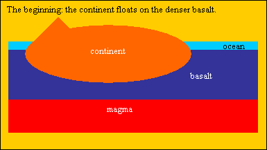 The continent is eroded by wind and water, removing rock from the high ares and depositing them in the low areas, particularly in the surrounding ocean, as can be seen where the Amazon River, Mississippi, Yangtze, Euphrates and Nile, where sedimentation has moved the coast hundreds of kilometers downstream.
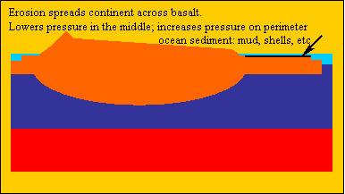 The pressure of sial on sima under the high areas, diminishes, while the pressure under low areas increases. With increasing pressure the basalt shifts to regions where the pressure is decreasing, that is, under the previously high areas of sial. This causes the sial to rise or 'float' higher.
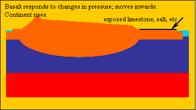 In this way, chalk and limestone beds on the ocean floor, can be raised high above the ocean, and after the layers above them are eroded, become chalk beds (as in the 7 Sisters on the coast of Dorset, England, or the spectacular limestone hills of southern China).
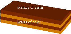 The continent's surface may be layers with sedimentary layers or it may, in a small region, be fairly uniform like one mass of granite or of basalt. These diagrams use layers to better show the points of this lesson. Please note that the diagrams are rough because of the limits of the software.
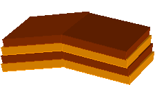 Under immense pressure and over a long time, a mass of rock can bend like a huge beam of concrete or a long steel pole. The diagram shows the bend as a sharp edge, but when you search your own countryside you will find all manner of bends, breaks, twists and contortions.
 Some layers are bent like swells running across a lake or sea. An anticline is a crest, a syncline is a depression. In this diagram which is which ?
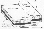
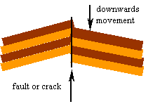 Here the forces are so great that that the layers are fractured (broken) vertically, and one section moves down relative to the other. The most convenient places to look for strata (layers), faults, anticlines, etc, are where roads and railways cut through hills.
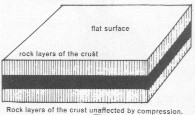 This diagrams shows layers you can find at the mouth of a slow river or on the ocean floor.
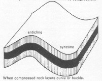 Here compression is bending the layers gently. Whole mountain ranges can be formed this way.
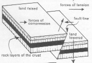 Compression is a force pushing sections together; tension is a force pulling them apart. A person hanging on a rope tied to a tree branch, exerts a tension or tensile or stretching force on the rope. A sack of rice on a person's head, exerts compression - you feel compressed.
 The Tibet Plateau, north of the Himalayas, has been pushed up because the Indian plate is pushing northwards against the Asian plate.
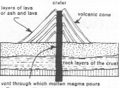 Volcanoes are formed by molten rock or magma, from deep underground, coming up through cracks in the crust, and pouring forth. As the rock cools and hardens, a mound is built. The mound might be solid rock or ash or alternate layers. Often the rock contains gas under high pressure. When the rock reaches the surface, the pressure suddenly comes off, the gas thus expands rapidly, effectively exploding and hurling molten lava high into the sky.
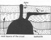 Huge volumes of magma (hot rock under high pressure) may sit deep within the ground, and are called batholiths. If the high pressure forces the magma into horizontal cracks where it cools and hardens, those horizontal deposits are called sills. Vertical ones are dikes. The overlying rock may be eroded after millions of years, exposing these sills and dikes for you to see. Your countryside probably has examples.
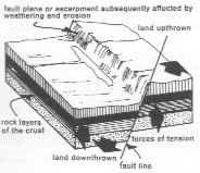 Faulting usually causes vertical movement of the crust. A normal fault is caused by tension, that is, the 2 blocks of rock have been pulled apart.
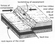 A reverse fault is caused by compression, causing one side to ride up over the other. The overhanging escarpment may then slip or landslide.
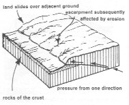 An overthrow thrust, produced by pressure from one direction, moves mostly horizontally with little vertical movement.
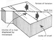 A tear, wrench or strike-slip fault, caused by tension forcing one block to slide horizontally along another. When large thses are called transcurrent faults, such as the San Andreas fault in California, as the Pacific Ocean plate grinds past the North American plate.
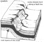 A monocline is caused by forces similar to those causing a normal fault, but instead of the rocks fracturing, the rocks bend sharply.
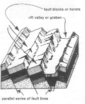 If there is more than one fault, and they run parallel, the block between the faults may sink to form a rift valley or graben. Or the block between the faults, may rise to form a fault block or horst.
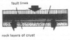
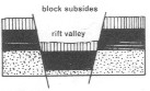
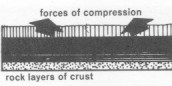 Compression
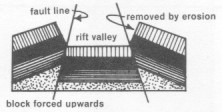
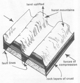 Where compression of 2 outer blocks force up an inner block to form a plateau or mountain range, this raised block is called a horst or horst block.
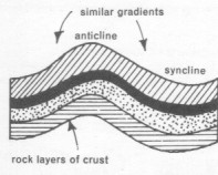 Folding is usually caused by horizontal compression forcing the layers to bend vertically.
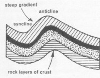 A simple fold is one where the angles of slope or gradients of the folding, are equal and not steep, acute (less than 900) perhaps less than 600.
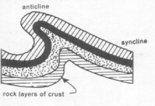 An overfold is formed when an asymmetrical fold keeps moving till the crest overhangs one side.
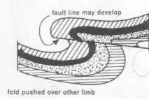 Fold mountains are usually much more complex than a tourist's view of scenic beauty would predict. Volcanic activity of bygone eras would usually have folded, torn, faulted and re-folded, with much erosion occurring simultaneously.
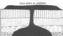 Because of tension and compression, the crust faults and folds, develops cracks, fissures and vents, particularly where one tectonic plate subducts under another. (See geology/plate tectonics.)
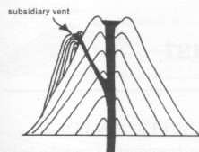 Increasing the pressure increases the temperature. If you descend a deep mine, the rock becomes hotter and hotter, requiring a cooling system for miners. Because pressure develops heat, the rock deep within the earth is under enormous pressure and therefore enormous heat. At high temperature and ordinary pressure rock is a liquid. Under high pressure the rock becomes a solid even though the temperature is still high. However, if this hot rock deep under the crust, finds a crack to the surface, the pressure is released, the rock turns to liquid and is squeezed upwards to the surface. This magma may simply exude quietly out over the plain and cool and solidify into hard black rock. Because it cools quickly, its crystals are very small, like those of basalt and rhyolite.
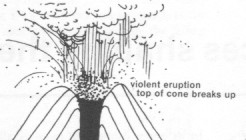 If some of its hot minerals, which may include water and carbon dioxide, vaporize when the pressure drops, that sudden vaporization can cause massive explosions at the volcano's vent or opening. Some gas-filled magma is shot into the air, cooling quickly enough to trap the gas inside, like pumice which is rock light enough to float on water. Tephra are pyroclasts thrown high into the air by violent eruption, the largest fragments being volcanic bombs from 32mm to 1m across.
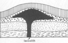 If the cracks do not have openings to the surface, the magma becomes trapped at a higher level and cools very slowly, perhaps over millions of years, enabling large crystals to grow, as in granite and gabbro.
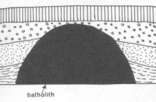 Batholiths are the largest intrusions, at least 100km2. The one batholith, when partly uncovered by erosion, may appear as several cupolas (domes) far apart.
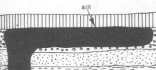
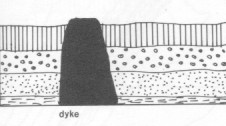
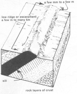 In this diagram the sill and adjacent rock has been tilted, then the overlying rock eroded to expose the sill. A big enough sill can form a ridge with an escarpment.
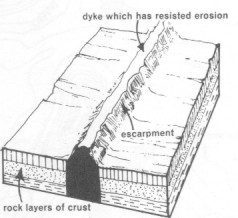
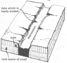 If the sill is softer rock, it will erode more quickly, leaving a depression.
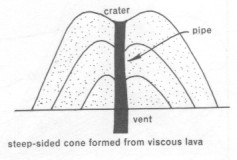 The slope of a volcanic cone depends upon the viscosity of the lava. If the lava is basaltic, what will the slope be ?
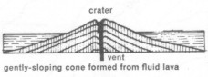
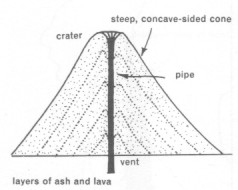 Composite cones of alternate layers of ash and cinder, resulting from lava being violently ejected with much gas and breaking into small fragments, are usually steep with concave sides.
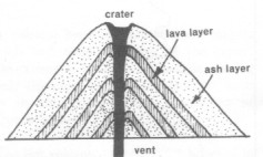 Composite cones of ash and lava, can occur if the magma alternatley exudes with and without the gas blowing it apart.
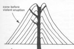 Many side vents make the cone susceptible to being blown apart.
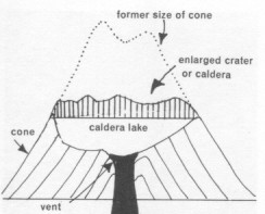
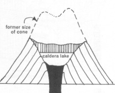
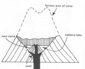
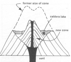
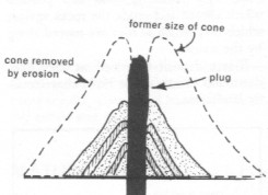
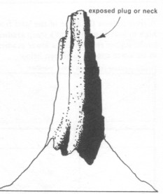
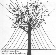 When a large enough cone is blown apart, later erosion can leave a flat center, often fertile and with a lake over the plug.