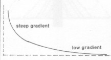
 In the hills the land is steep, the water rapid, the erosion intense, the valleys steep-sided and V-shaped. The waterfalls occur in the steep-gradient upper-course of the river. As the slope or gradient decreases, the water flow slows, and the valley flattens. In the lowlands, deposition of silt and gravel produces an alluvial plain. As the alluvial plain matures, the river winds more and more, forming a sine curve with minimum energy loss, maximum deposition, and often forming oxbows. The more a river curves and winds, the more mature it is. |
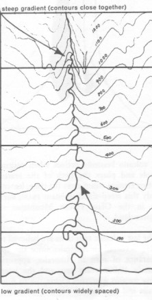 Since the contours (those wiggly lines going across the diagram) representing the same height above sea-level, the closer the lines, the faster the land is dropping away, and the steeper the land. This makes the water flow fast and fairly straight, except where hard rock turns it.
Lower down, where the contour lines are further apart, the land becomes almost flat or level, so the water slows and if there is no hard rock to define its channels, the water will carve a sinuous path through the soft soil.
If the land is level, the mature lowland often becomes floodplain, marsh, a delta or mangrove.
Study this map to relate the shape of the river to the changes in contour. Relate these to rivers in your district. If your rivers are different, then find reasons to explain the differences. |
The next 3 diagrams show how the river valley is usually steep-sided and V-shaped in the upper section, then continually flattens further down, as the river reduces its erosion and increases its depositing of gravel and silt.
|
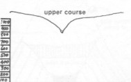
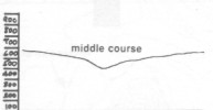
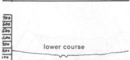
|
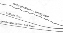 In this diagram on the right, there are 3 stages of evolving maturity of a river, as the river reduces its slope or gradient by eroding the riverbed from steep when young to gentle when mature. |
Young valley
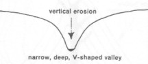 In the youthful river, the steepness produces fast flows with the force to gouge around rocks and sweep them away, helped by the buoyancy of water. Vertical erosion is dominant in the early stage. |
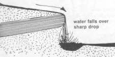
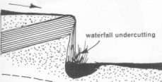
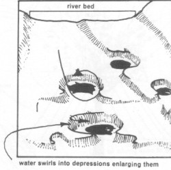 The fast flows swirl large cobbles and pebbles around in eddy currents, abrading the surrounding rock to produce potholes and undercut waterfalls. |
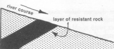 A layer of hard rock, slow to erode, forms a shelf when the softer rock downstream becomes eroded. |
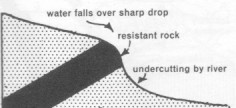 Initially this forms rapids which can eventually become a waterfall. |
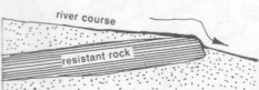 |
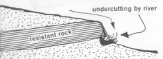 As soon as a groove appears in the rock below the resistant rock, pebbles will gather, being trapped and swirled around. This abrades the lower rock, eventually forming a deep groove. (Look for some in your river, along with cylindrical potholes.) |
 |
 |
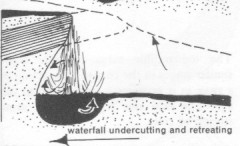 |
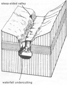 A steep valley or gully will concentrate the river over a narrow waterfall. As the waterfall is undercut, and this undercut retreats upstream, a gorge is formed. |
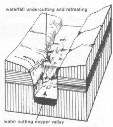 This gorge becomes deeper and longer. |
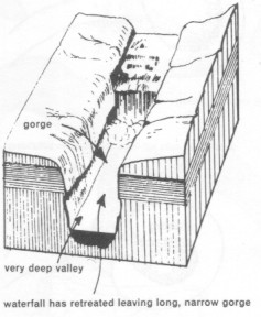 |
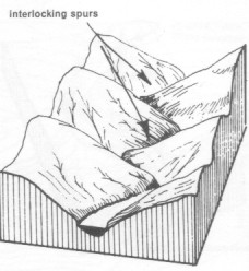 Water follows the path of least resistance. When young, before time allows undercutting of rock, a river will curve around any hard rocks, simply following the lowest path between interlocking spurs. |
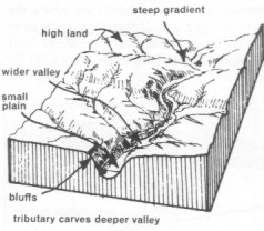
Mature valley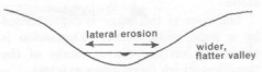 A mature valley is wider and flatter, with few waterfalls and rapids. It shows sideways erosion and depositing of pebbles, gravel and sand. |
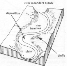
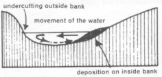 Cutting may be pronounced on the outside of river bends where flow is greater, while on the inside there may be a bank of pebbles and gravel, with a back eddy downstream. |
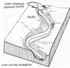 This undercutting of the outer bends produces high faces called bluffs (high steep banks). |
Old valley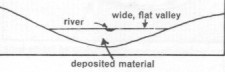 In old valleys, much alluvial soil has been deposited to form a flat valley with a sinuous river winding its way slowly. Water flowing in a sine curve, is exhibiting minimum energy loss through erosion damage. |
 |
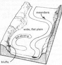 |
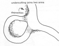
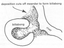
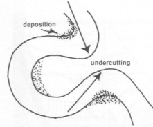 When a river bend winds back on itself, it is called an ox-bow. A heavy wet season might produce such a large and fast waterflow that the neck is washed away. This straightens the river and, by deposition of wet-season erosion from upstream, isolates it into a stagnant ox-bow or billabong. As it evaporates in the dry season, fishing is easy. |
 |
 |
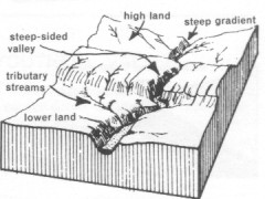 These 3 diagrams show the same stretch of river evolving through young-mature-old stages. |
 |
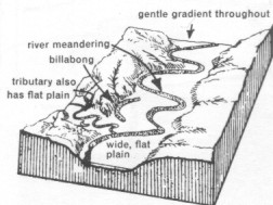 |
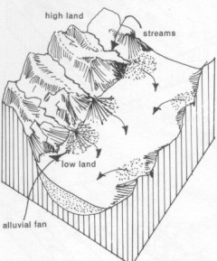
Alluvial fans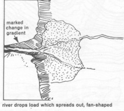 Alluvial fans occur:
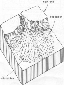
- when a gradient suddenly changes from steep to gentle, resulting in a sudden change in rate of flow, and deposition of sediment
- a narrow valley meets an open plain, allowing the water to suddenly fan outwards, and therefore slow and deposit sediment.
|
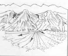
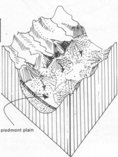
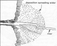 Alluvial fans occur at the bottom of escarpments, where hills meet a flat desert |
 |
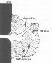 As sediment blocks streams, the river then has to cut through, forming distributaries, and then extending the delta even further. Each wet season flood brings higher deposits until the land is raised sufficiently for people to live precariously on it. The rains leach the sea salt out of the soil, making farming possible.
The big examples whose deltas have added hundreds of kilometres of farmland to the coast, are the mouths of the Ganges and Brahmaputra (Bangladesh), Irriwaddy (Burma), Chao Phraya (Thailand), Mekong (Vietnam), Yangtze and Hwang (China), Mississippi (US), Nile (Egypt), Niger (Nigeria), and Euphrates and Tigris (Iraq). |
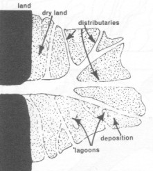 The heavy price for new fertile land is the disastrous flooding which causes drowning, disease and starvation. As global warming causes the seas to rise, this flooding will occur more and more frequently till these huge tracts of land are permanently underwater. Where will those millions of people go ? How will they feed themselves ? |
Deltas |
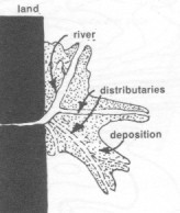 Deltas are formed by rivers carrying much sediment, and the sea slows the current long enough to drop that sediment. Mangroves are excellent for protecting the silt from erosion due to wave action and sea-currents. |
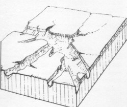
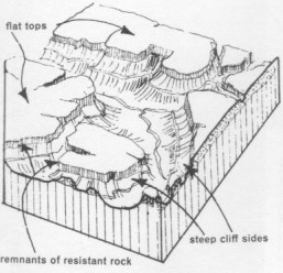
Erosion cycle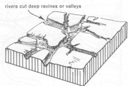 These 4 diagrams show the weathering from early or new landform to advanced or the peneplain not far above sea level. The monadnocks are mounds of resistant rock. |
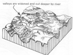 |
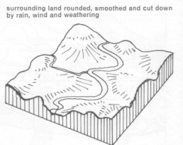 |
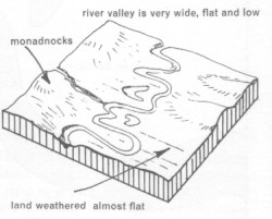 |
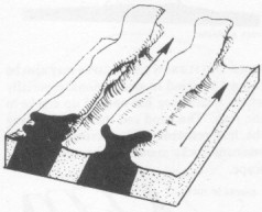
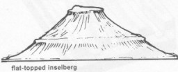
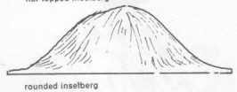
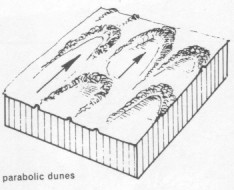
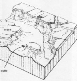
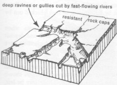 These 3 show the erosion cycle in an arid climate. In arid zones, rivers are usually dry, but thunderstorms produce flash-floods, 'instant waves' crashing along the dry watercourses gouging steep banks and sweeping all before them.(People who like the riverbed for easy camping can be swept away without warning.) |
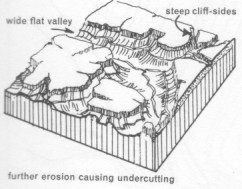 |
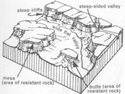 |
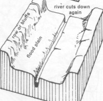
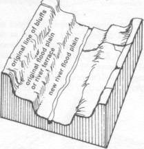
The last 4 diagrams (below) show an old river valley, having been uplifted and given increased gradients, now being re-eroded to form entrenched meanders and the surviving edges of the old river bed being left high up as river terraces.
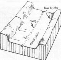 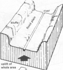 |
  |
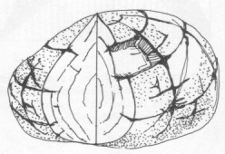
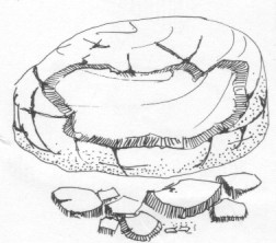
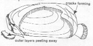 You might find rock with layers peeling off. This peeling of layers, like an onion, is called exfoliation. Hot sun can cause the outer rock to expand more rapidly than the inner rock, causing cracks to develop parallel to the surface like layers, which eventually peel off. Exfoliation may be caused by water seeping into surface cracks and then freezing. As water freezes, it expands, forcing the outer layer to peel off.
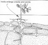 On cliffs, you might see tree roots forcing their way down cracks in rocks, opening them little by little, allowing water to seep down and dissolve the minerals, further opening the cracks.
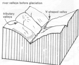 It is obvious that the climate of a country depends on its location on the globe, but we need to remember that that location changes by, say, 50mm per year. After 1 million years, it has moved 50km and after 100 million years, some 5000km.
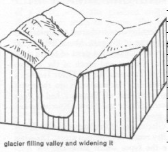 An ice age may produce glaciation, that is, large sheets of ice (ice caps) or valleys of ice.
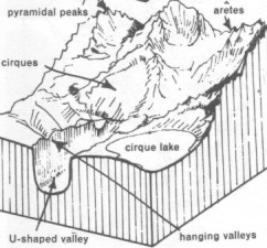
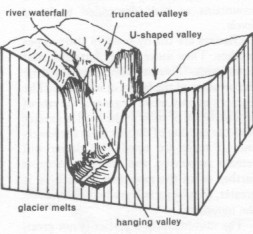 Tributary valleys, where they enter the glaciated valley, become truncated (cut back), so that, when the ice melts and disappears, they form hanging valleys, usually with magnificent waterfalls plummeting many meters.
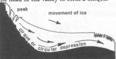 The ice from the peak, a long length bearing almost vertically downwards, erodes deep hollows at the head of the valley (cirque). When the ice melts, this cirque fills with water, forming a cirque lake at the head of the glaciated valley.
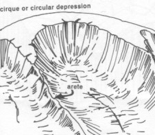 Snow accumulates at the upper levels, perhaps on a mountain top recognizable by its cirques, aretes (sharp ridges) and pyramidal peaks. As the snow and ice increases with more snowfalls, its own weight compresses it into ice. The rock at the mountain peak freezes, cracks and falls away, forming aretes.
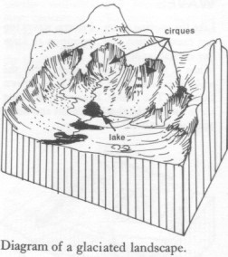
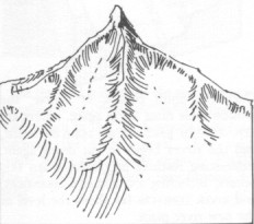 2 adjacent cirques will form a ridge between them. The peak, its outer layers penetrated by water which freezes, expands and shatters the outer rock, forming a steep peak. Where 3 cirques surround the peak, a pyramidal peak or col is formed.
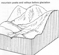 Decide how the transformation occurs.
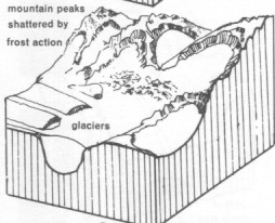 A glacier abrades rock, picking up the eroded material, along with bigger rocks and even huge boulder which come tumbling down the slopes.
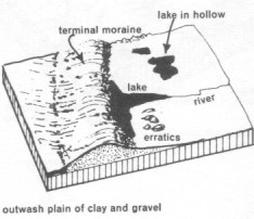 When the glacier melts all the rubble is deposited in a big heap stretching across its path, across the valley, perpendicular to its direction of travel. Such a deposit is called a terminal moraine.
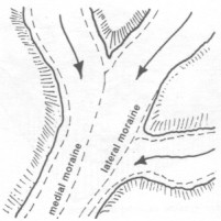 Moraines may also form where two glaciers meet (medial moraine), including where a tributary glacier joins a bigger glacier (lateral moraine).
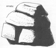 Sometimes a huge boulder, called an erratic, will be found on a flat plain, where a glacier dropped it, all alone. Look for tell-tale scratch marks in its rock.
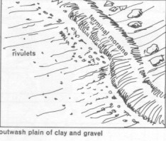 A large outwash plain of clay and gravels may form in front of terminal moraines. This material has probably been carried forward by water melting from the stationary glacier.
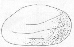
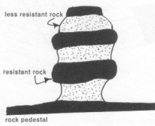 Rock pedestals are abraded by wind-carried sand, and therefore often narrower at the base where the sand is more concentrated.